Blog · Safety
Through the Cajon Pass: Flying to the High Desert From Redlands
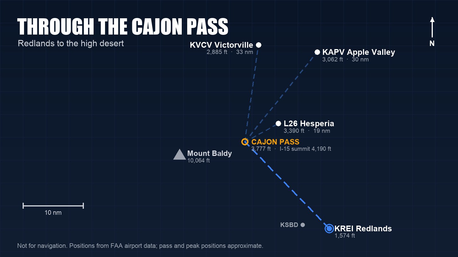
The Cajon Pass is the high desert's front door. From Redlands Municipal (KREI) it lies about 20 nautical miles northwest, and on the other side are three airports worth knowing: Hesperia, Apple Valley, and Southern California Logistics Airport at Victorville. The flight is short and scenic, and it's a real lesson in terrain and wind.
The pass
The Cajon Pass separates the San Gabriel Mountains to the west from the San Bernardino Mountains to the east. Its low point is 3,777 feet, and Interstate 15 crosses nearby Cajon Summit at 4,190 feet. Mount San Antonio, better known as Mount Baldy, rises to 10,064 feet about 11 nautical miles west of the pass.
Interstate 15 and two rail lines run through the pass, so it's easy to follow from the air. The airports on the far side all sit high: Hesperia (L26) at 3,390 feet, Apple Valley (KAPV) at 3,062 and Victorville (KVCV) at 2,885. Coming from Redlands at 1,574 feet, you're climbing to a desert floor 1,300 to 1,800 feet higher than home.
Altitude and terrain
Plan an altitude that clears the summit and the nearby ridges with generous margin, not just the low point of the pass, and think about where you'd go if the engine quit. When you're more than 3,000 feet above the surface, use the VFR cruising altitudes in 14 CFR 91.159: odd thousands plus 500 feet on magnetic courses from 0 to 179 degrees, and even thousands plus 500 from 180 to 359.
Clouds sometimes sit on the ridges or fill the pass while it's clear on both sides. If the pass is obscured, don't try to squeeze under the clouds. Turn around, or wait.
Wind and turbulence
The pass funnels wind. On many afternoons, air flows from the basin up through the pass toward the desert. During a Santa Ana the flow reverses, and the Cajon Pass becomes one of the main channels for dry northeast wind racing toward the coast. Either way, expect mechanical turbulence downwind of the ridges, and expect the wind on the far side to be different from the wind at Redlands.
Check the winds at Victorville and Apple Valley before you go, look for an AIRMET Tango, and set a wind limit you'll actually turn around for.
Density altitude
Summer afternoons in the high desert are hot, and those airports already sit near 3,000 feet. On a 100°F day at Hesperia, the density altitude is nearly 7,000 feet. A Cessna 150 or 172 will take a lot more runway and climb far more slowly than it does at Redlands on a cool morning.
Fly early in the day in summer, run the numbers from your airplane's performance charts for the actual temperature, and follow your handbook's guidance on leaning the mixture for takeoff at high-elevation airports.
The airports
Hesperia (L26) is about 19 nautical miles from Redlands, with one runway, 3/21, 3,910 by 50 feet. The CTAF is 123.0. The FAA lists the runway in poor condition and notes a slight uphill grade to Runway 21, rising terrain to the south, public road access to the runway in several places, and Runway 21 as the calm-wind runway.
Apple Valley (KAPV) is about 30 nautical miles from Redlands, with a 6,498-foot Runway 18/36 and a 4,100-foot Runway 8/26. The CTAF is 122.8. The FAA notes hills to the north, east and west, and aerobatic training northeast of the airport. Joshua Approach on 124.55 covers the area if you want flight following.
Southern California Logistics (KVCV) at Victorville is about 33 nautical miles from Redlands. It's the former George Air Force Base, with runways of 13,052 and 9,138 feet and a control tower on 118.35, open from 6 a.m. to 8 p.m. The ATIS is on 135.475. The airport is home to a large aircraft storage and maintenance operation, so expect to see rows of parked airliners. The FAA asks pilots to avoid overflying Silver Lakes, about 10 miles north, for noise abatement.
The bigger picture
North of Victorville, the high desert holds large restricted areas around Edwards Air Force Base and Fort Irwin. Check the current sectional and stay well clear of them.
None of these three airports is 50 nautical miles from Redlands, so a trip to them doesn't count as cross-country time for a private, commercial or instrument certificate (14 CFR 61.1). Barstow-Daggett (KDAG), at about 49.5 nautical miles, misses as well.
Before you go
- Check the winds on both sides of the pass, and any AIRMETs for turbulence.
- Plan an altitude for the terrain, not just the pass.
- Work out density altitude and takeoff distance for your destination's temperature.
- Check NOTAMs and the restricted areas on the sectional.
- Fly it the first time with an instructor.
Cornerstone Flight Academy rents a Cessna 172 and a Cessna 150 at Redlands Municipal Airport, and our instructors can fly the pass with you before you go on your own.
Call or text (909) 330-4748, or visit flycornerstone.com.
Book a $120 intro flight · Aircraft rental and time building · Pilot training at Cornerstone · More from the blog