Blog · Safety
Santa Ana Winds and Flying in the Inland Empire
Santa Ana winds turn Southern California's usual weather around. Instead of a gentle sea breeze from the west, dry air pours down from the high desert toward the coast, squeezing through the mountain passes on either side of the Inland Empire. If you fly out of Redlands, Santa Ana winds are one of the local weather patterns most worth understanding, and fortunately one of the easiest to see coming.
What a Santa Ana is
A Santa Ana sets up when high pressure builds over the Great Basin while pressure is lower along the coast. Air flows from high to low: out of the deserts, over and through the mountains, and down toward the ocean.
As that air descends it's compressed and warms, by about 5.4°F for every 1,000 feet, and its relative humidity drops, sometimes below 10 percent. The passes squeeze the flow and speed it up. Around the Inland Empire, the Cajon Pass northwest of Redlands and the San Gorgonio Pass to the east are two of the best-known channels.
Santa Anas are most common from October through March, and a single event can last anywhere from a day to about a week.
What it does to a light airplane
- Strong, gusty surface winds. Speed and direction can change from one moment to the next, especially near the passes and foothills.
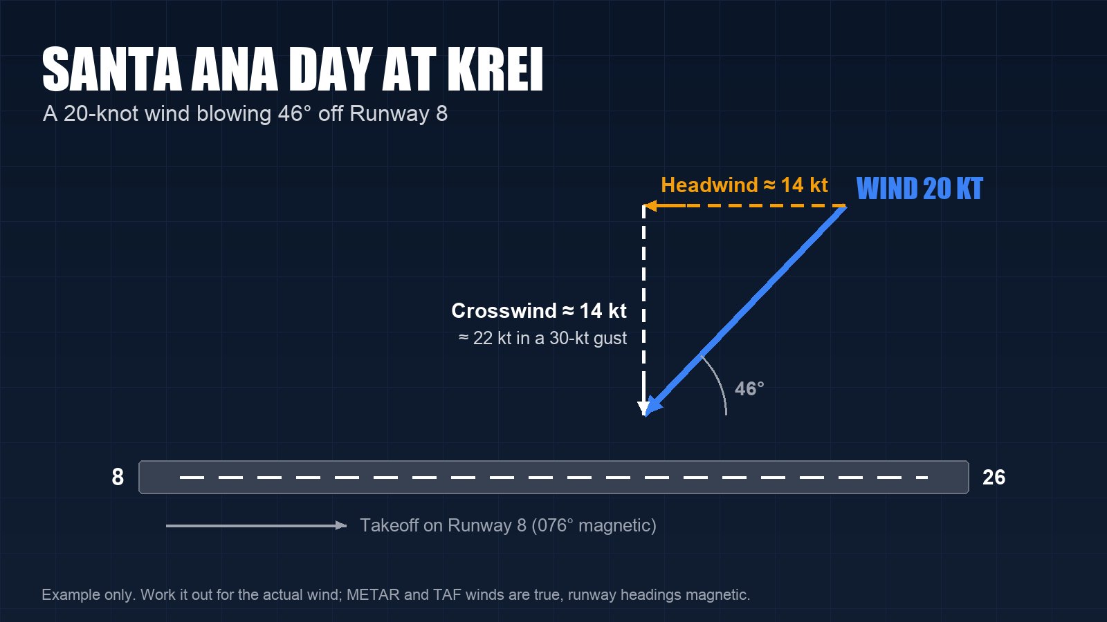
- Crosswinds at Redlands. KREI's only runway, 8/26, runs east and west. Santa Ana winds blow from the northeast quadrant, so at Redlands much of the wind can come across the runway instead of down it.
- Turbulence and wind shear. Wind pouring over ridges and through passes tumbles on the downwind side. Expect mechanical turbulence near the mountains and passes, and be ready for low-level wind shear on climb-out and final approach.
- Mountain waves. In strong events, the flow across the San Gabriel and San Bernardino Mountains can set up waves, with powerful up- and downdrafts downwind of the ridges.
- Dust and smoke. Blowing dust can cut visibility, and Santa Ana days are wildfire days.
Do the crosswind math
Runway 8 points 076 degrees magnetic and Runway 26 points 256. A 20-knot wind blowing 46 degrees off the runway gives a crosswind component of about 14 knots, and a gust to 30 knots raises it to about 22. Compare that with your own limits and with the maximum demonstrated crosswind in your airplane's handbook before you go, not on short final.
Remember that METAR and TAF winds are reported in degrees true, while runway headings, ATIS and automated weather broadcasts use magnetic. Around Redlands the difference is more than 10 degrees, enough to change the math.
Many instructors also teach adding half the gust factor to your approach speed on a gusty day. Ask yours how they want you to fly it in a Cessna 172 or 150.
Fires and flight restrictions
When a wildfire starts, the FAA often publishes a temporary flight restriction (TFR) around it under 14 CFR 91.137, so firefighting aircraft can work low and fast. Air tankers and helicopters may be flying anywhere nearby. Check the FAA's TFR list and the NOTAMs before every flight on a Santa Ana day, and again before you head home. Smoke can drop visibility below VFR minimums and hide terrain, sometimes far from the fire itself.
How to see one coming
- National Weather Service products. The NWS office in San Diego, which covers the Inland Empire, issues Wind Advisories, High Wind Warnings and Red Flag Warnings ahead of strong events, and its Area Forecast Discussion often flags Santa Ana conditions days in advance.
- AIRMET Tango. It covers moderate turbulence, sustained surface winds of 30 knots or more, and low-level wind shear.
- TAFs and METARs. San Bernardino (KSBD), Ontario (KONT) and March Air Reserve Base (KRIV) issue TAFs; Riverside (KRAL) reports METARs. Look for gusts, wind shear groups (WS) and winds swinging around to the north or east.
- Winds aloft forecasts. Strong northeast or easterly winds at the lower altitudes are a giveaway.
- PIREPs from pilots who have already been up.
Go, no-go and what to fly instead
Set crosswind and gust limits with your instructor before the season starts, and treat them as limits, not targets. A cancelled flight is a good decision on a Santa Ana day.
If the wind is strong but steady and inside your limits, a dual lesson focused on crosswind technique is a good use of the day. If you're already flying and the wind at Redlands has picked up beyond what you planned for, divert. Know which nearby airports have a runway that lines up better with a northeast wind than Redlands' east-west runway, such as Runway 3/21 at Chino (KCNO), and check their winds before you count on them.
When a Santa Ana ends, the onshore flow can return quickly, and coastal airports can go from clear to fog in a short time. Plan any trip to the coast with that in mind.
Flying out of Redlands on a windy day
Get a full weather briefing before every flight, and on a Santa Ana day look at the whole route, not just KREI. If you'd like to build crosswind skills in a Cessna 172 or 150 with an instructor, or talk through a flight you're planning, we're glad to help.
Call or text (909) 330-4748, or visit flycornerstone.com.
Book a $120 intro flight · Aircraft rental and time building · Pilot training at Cornerstone · More from the blog