Blog · Community
Flying to Palm Springs (KPSP) From Redlands
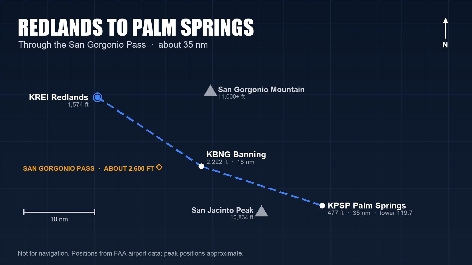
Flying to Palm Springs from Redlands is one of the best short trips in the Inland Empire. Palm Springs International (KPSP) is about 35 nautical miles east-southeast of Redlands Municipal (KREI), and the route takes you through the San Gorgonio Pass, between the two highest peaks in Southern California, and out over the desert. It's short enough for a lesson and interesting enough to teach you something every time.
The route through the pass
The natural way east is the Interstate 10 corridor through the San Gorgonio Pass, also called the Banning Pass. It's a gap about 2,600 feet high between the San Bernardino Mountains to the north and the San Jacinto Mountains to the south. San Gorgonio Mountain, at more than 11,000 feet, stands north of the pass, and San Jacinto Peak, at 10,834 feet, rises to the south, right above Palm Springs.
Banning Municipal (KBNG) sits in the pass about 18 nautical miles from Redlands, at 2,222 feet. It makes a good checkpoint, and its automated weather on 134.625 tells you what the pass is doing. If you plan to land there, note the FAA remark that Runway 8/26 has no straight-in landings.
Past Banning, the pass opens into the Coachella Valley and the terrain drops quickly toward Palm Springs, which sits at 477 feet.
Wind in the pass
The San Gorgonio Pass is one of the windiest places in the country, which is why one of California's large wind farms is there. Air often flows from the coast toward the desert through the gap, especially in the afternoon, and it can be strong and rough. Eastbound, that usually means a tailwind and a bumpy ride; westbound, a headwind. On Santa Ana days the flow can reverse and pour toward the coast instead.
Before you go, check the winds at Banning and Palm Springs, look for an AIRMET Tango, and give yourself room above the terrain. If the pass is turbulent beyond what you're comfortable with, turning around is a perfectly good flight.
Talking to Palm Springs
Palm Springs has a control tower on 119.7, open from 6 a.m. to 11 p.m., and ATIS on 124.65. Listen to the ATIS, then call the tower well before you reach its airspace. When the tower is closed, 119.7 serves as the common traffic advisory frequency. In the area, SoCal Approach handles 8,000 feet and below on 135.275 if you want flight following.
The airport has two parallel runways: 13R/31L, 10,000 feet long, and 13L/31R, about 4,950 feet. You'll share them with airline and business-jet traffic, so listen for the runway the tower assigns and expect to be sequenced with faster airplanes. A few things from the FAA's airport remarks are worth knowing before you arrive:
- Rising terrain lies north of the approach end of Runway 13R.
- Don't mistake the center taxiway, Taxiway C, for Runway 13R/31L.
- Noise-sensitive areas surround the airport, so the FAA asks pilots to use quiet flight procedures.
Desert heat
Palm Springs sits low, but summer afternoons there are hot, and heat raises density altitude. At 110°F, the density altitude at Palm Springs is around 4,000 feet, so a Cessna 150 or 172 climbs noticeably more slowly than it does on a cool morning. In summer, fly early, check your airplane's performance charts for the actual conditions, and carry water.
What's there
The Palm Springs Air Museum sits right next to the airport, with hangars of historic military aircraft. 100LL is available on the field. Ask the FBO about parking and any fees before you go.
Make it a training flight
Palm Springs is a good first towered destination for a student with an instructor: a real control tower, a long runway, airline traffic to listen to, and a mountain pass on the way. Along the route you can practice pilotage along Interstate 10, flight following with SoCal, and a towered arrival and departure, all in under an hour of flying each way.
It doesn't count as cross-country time for a certificate, though. For a private, commercial or instrument certificate, a cross-country flight has to land somewhere more than 50 nautical miles in a straight line from where it started (14 CFR 61.1). Palm Springs is about 35 nautical miles from Redlands, and Bermuda Dunes (KUDD), at about 48, also falls short. Continue down the valley to Jacqueline Cochran Regional (KTRM) in Thermal, about 56 nautical miles from Redlands and 114 feet below sea level, and the trip counts.
Before you go
- Check NOTAMs and TFRs for the Coachella Valley.
- Plan your altitude for the terrain on both sides of the pass, not just the pass itself.
- Check the winds in the pass and the temperature at Palm Springs.
- Plan fuel for a headwind on the way home.
Cornerstone Flight Academy rents a Cessna 172 and a Cessna 150 at Redlands Municipal Airport, and our instructors can fly the pass with you the first time.
Planning a trip east? Call or text (909) 330-4748, or visit flycornerstone.com.
Book a $120 intro flight · Aircraft rental and time building · Pilot training at Cornerstone · More from the blog